
Page 144 - AC/E Digital Culture Annual Report
P. 144
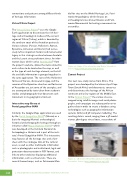
144connections and patterns among di erent kinds of heritage information.Virtual Cilicia ProjectThe Virtual Cilicia Project86 uses the Google Earth application to disseminate the rich heri- tage and archaeological studies of the ancient region of Cilicia (Turkey), which is bounded by the southern coast of the Anatolian peninsula. Various cultures (Persian, Hellenistic, Roman, Byzantine, Armenian and Islamic) had succes- sively left an important historic and monumental legacy in this strategic enclave between Anatolia and the Levant since prehistoric times. An infor- mation layer, which can be downloaded87 from the project’s website, allows the items related to each culture to be located on the map, as wellas the type of each heritage element, so that all the available information is grouped together in the same application. The ruins of the Hellenistic fortress of Karasis, discovered in 1994, and the remains of the Byzantine churches and fortresses of Anazarbos are just some of the examples, and are accompanied by texts taken from academic studies and photographs that document each monument in its geographical context.Interactive map library at Portal geográ co-INAHSimilarly, the Google Maps application was used by the Portal Geográ co-INAH88 (Mexico) as a basis for mapping Mexico’s archaeological, historical and ethnographic heritage through an initiative called Mapas Digitales-INAH,89 which was developed at the Instituto Nacional de Antropología e Historia and is part of the insti- tute’s Portal Geográ co-INAH. This interactive map features all the heritage sites and a fact- sheet with the catalogue data of the cultural asset, as well as other multimedia information such as photographs and institutional, legal and protection documentation in PDF format, and links to other websites displaying additional information, such as virtual visits. There are several themed maps, such as Patrimonio Mun-dial for sites on the World Heritage List; Patri- monio Arqueológico, which focuses on archaeological sites all over Mexico; and Patri- monio Monumental for heritage monuments or ensembles.Figure 04 - Image of the interactive map library. Screenshot. Source: http://www.geoportal.inah.gob.mx/Zamani ProjectOur next case study comes from Africa. This project was developed by the University of Cape Town (South Africa) and documents, conserves and disseminates the heritage of the African continent and a few regions of the Middle East. In the Zamani Project90 the various sites are mapped using satellite images and aerial photo- graphs, and campaigns are subsequently run to gather data in order to create a database using technologies such as geographic information systems (GISs) and 3D computer modelling. The resulting data is varied, ranging from a 3D model viewer, 360-degree virtual tours, screenshots ofFigure 05 - 3D model of Beta Abba Libanos in Lalibela (Ethiopia). Screenshot. Source: http://zamaniproject.org/%5D2. DISSEMINATION, ENHANCEMENT AND EDUCATIONThe use of digital technologies in the conservation, analysis and dissemination of cultural heritage
